University of Calgary
Geospatial Sensing and Intelligence Lab (GSIL)
Research Statement
With substantial investment in sensor development and platform deployment, the Remote Sensing (RS) industry has grown into a billion-dollar global market, and is still on the verge of a massive growth spurt. An increasing number of government agencies, research institutions and commercial companies leverage the big RS data to advance climate change and environment monitoring applications.
Nevertheless, the application of the big and ever-increasing RS data is bottlenecked by the limited ability of data processing techniques and software tools to effectively transform the data into value-added information, products and services.
Therefore, the development of advanced AI and machine learning (ML) techniques that can effectively and efficiently derive meaningful information from RS data can greatly expand and enhance the applications of big RS data, improve the decision-making in climate change and environmental applications, enlarge the RS market with various new business models and customers, and create tremendous opportunities and growth for RS and geospatial industries.
In GSIL, we focus on the development of advanced AI & ML algorithms, models and systems for computer-aided processing and analysis of RS data to efficiently and effectively extract the weak, subtle and changing information from big complex RS data that can better support many environmental monitoring and climate change applications.
Hyperspectral Environmental Remote Sensing
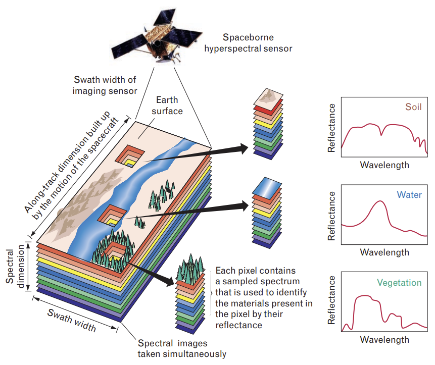
Hyperspectral imaging, which records the reflected radiation from the earth surface using hundreds of narrow spectral bands, can provide rich information for identifying and distinguishing spectrally-similar materials, and has become an essential tool leveraged by research scientists and operational users to retrieve key parameters (e.g., biochemical, biophysical and geochemical parameters) in various environmental monitoring and resource exploration applications.
Nevertheless, due to the large data volume, the innate high-dimensionality, spatial-spectral heterogeneities and the noise effect of hyperspectral image (HSI), there are significant challenges for users to efficiently and accurately transform HSI into value-added information. To address these challenges, I and my HQPs have been developing novel ML, DL and spectral analysis models and methods for achieving computer-aided processing and analysis of the large-volume complex HSI that can significantly improve the quantification of valuable bio/geo-variables, and thereby improve environmental monitoring and resource exploration.
Intelligent Hyperspectral Analytics
We develop novel DL/ML and spectral analysis models to improve many different HSI processing tasks, e.g., HSI classification, spectral unmixing, HSI denoising, feature extraction and visualization. We implement these algorithms into advanced HSI software tools to facilitate the development of data processing workflows, pipelines and analytic solutions to key HSI applications. We use UAV/drone hyperspectral systems with Cubert UHD185 and Resonon Pika XC2 hyperspectral cameras to collect HSI on vegetated and industrial areas for vegetation monitoring and pollution investigation. We use the PRISMA satellite hyperspectral images for mineral and vegetation mapping. We develop data processing pipelines to improve the processing and analysis of UAV and satellite hyperspectral imaging data. We develop hyperspectral cameras based on the openHSI project https://openhsi.github.io/. We collaborate with Canadian industries, e.g., SkyWatch in Kitchener, to help them build intelligent analytics that can efficiently and accurately generate information products in crop mapping, mineral exploration and methane emission monitoring applications. We have been and will continue publishing on high-rank remote sensing journals and conferences, and developing intelligent HSI analytics to improve environmental monitoring and resource exploration applications in Canadian industries in a fast-growing hyperspectral remote sensing market.
Lost-cost DIY hyperspectral camera and AI software
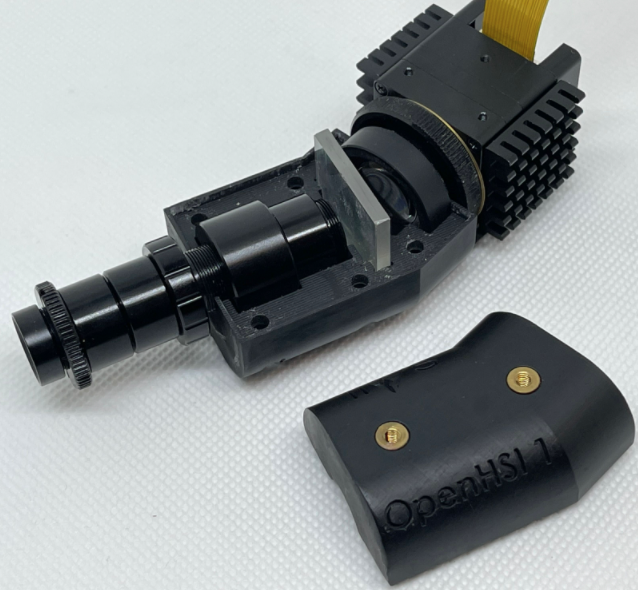
We develop low-cost DIY hyperspectral cameras based on the openHSI project https://openhsi.github.io/. We design indoor benchtop hyperspectral imaging system to support smart factory, machine vision and industrial inspection applications in food, garbage inspection and mining industries. We deisgn outdoor UAV hyperspectral imaging system by integrating the DIY camera with other sensors, e.g., GPU, IMU and LiDAR, to better support various environmental monitoring applications, e.g., precision agriculture and forestry, water quality monitoring and resource exploration. Based on our strong experties on spectral analysis and AI, we design AI-powered software systems, leading to integrated intelligent hyperspectral systems that can achieve fast and accurate processing of big hyperspectral data in the above-mentioned applications.
SAR and Optical Remote Sensing of Canadian Water and Ice Environment
Satelliet synthetic aperture radar (SAR) and airborne high-resolution optical images have been widely used in the monitoring of the Canadian water and Northern ice environment to support many critical applications, e.g., e.g., climate change studies, coastal environmental management, indigenous communities, and Arctic shipping route planning and navigation. Nevertheless, efficient extraction of sea/lake ice, oil spill and whale information from these images is difficult due to many challenges, such as large data volume, noise effects, the complex marine environment, and weak signatures of targets. To address these challenges, I and my HQPs have been using advanced ML and deep learning (DL) techniques to develop advanced image processing models and algorithms to better support sea/lake ice mapping, oil spills monitoring and whale detection.
Pan-Arctic sea ice mapping and prediction software system
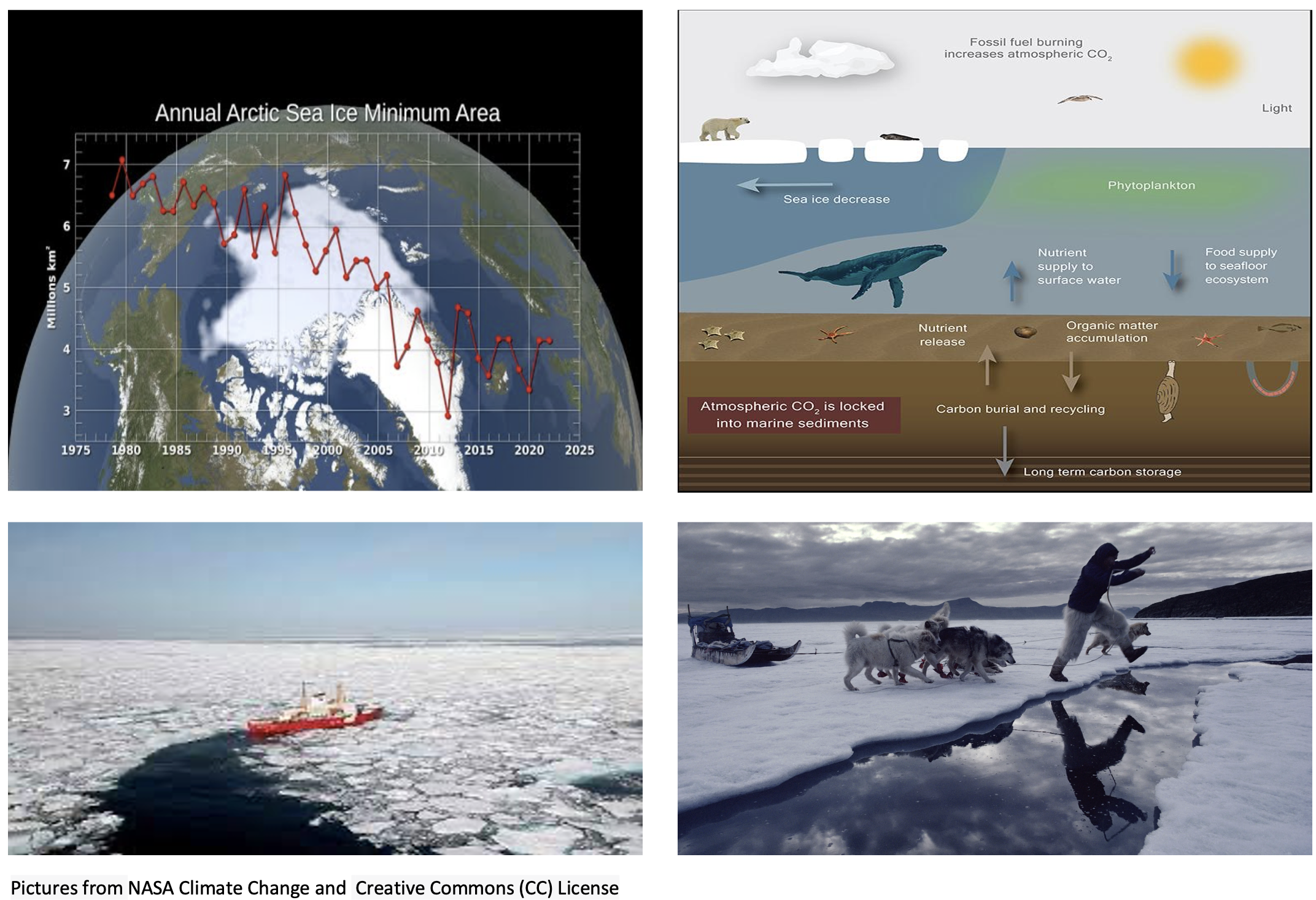
The monitoring and mapping of Arctic sea ice is not only critical for climate change studies and Arctic ship navigation, and but also critical for protecting the fragile Arctic ecosystem. Arctic is home to a unique and fragile ecosystem that is highly sensitive to changes in the ice cover. As the ice melts, it disrupts the food chain and habitat of many species, including polar bears, seals, and walruses while also affecting the lives and traditions of indigenous communities residing in the region. So, monitoring Arctic sea ice can help us to better understand how climate change is affecting this sensitive region, and how to better mitigate its impact.
For SAR sea/lake ice mapping, we develop advanced DL and image analysis algorithms for improving SAR image denoising, SAR image segmentation and object-based SAR image classification that enable a complete data processing pipeline for large-scale high-resolution daily Pan-Arctic SAR ice mapping. Our advanced AI algorithms enabled us to win the 1st place in the AutoICE competition, which is one of the AI4EO challenges (https://platform.ai4eo.eu/auto-ice ) organized by the European Space Agency (ESA), aiming to improve operation sea ice charting using AI.
We have been and will continue publishing on high-rank remote sensing journals and conferences, implementing designed algorithms into software tools to help companies (e.g., WhaleSeeker) and government agencies, e.g, Canadian Ice Service (CIS), Department of Fisheries and Oceans (DFO), and indigenous communities, e.g., the Indigenous Knowledge Social Network (SIKU), in operational sea/lake ice mapping, oil spills monitoring and whale counting.
Marine oil spills detection system
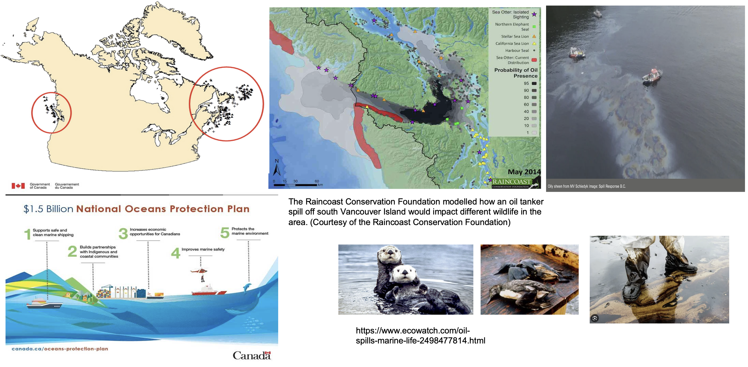
Marine oil spills are produced by tankers or drilling platforms, which can be accidental or deliberate. The presence of oil spills pollute the sea water, destroy wildlife habitat and breedingground, and damage beaches, causing many social and ecological problems. Canada borders three oceans and owns the world’s longest coastline, and as such is particularly vulnerable to oil spill pollutions. Significant efforts have been undertaken to improve Canada’s ability in marine oil spills monitoring and quick response. For example, in year 2016, the federal government announced a $1.5 billion national Oceans Protection Plan to improve responses to oil spills in Canadian oceans. Addressing oil spill pollutions is one of its key objectives. In 2022, the ocean protection plan was extended with a new budget of $2 billion over the next nine years. These investments reflect the importance and urgency of marine oil spill monitoring and response.
For SAR oil spill monitoring, we develop advanced ML and computer vision algorithms that accurately identify the boundaries of the potential oil spills from noisy SAR imagery. We compare and optimize different classifiers to improve the classification of true oil spills from the "look-alikes". We develop active learning and semi-supervised learning approaches to improve model training using limited training samples.
Arctic species detection system
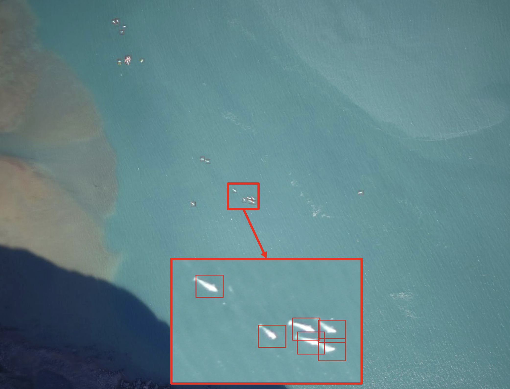
The beluga, also known as the white whale, is a toothed whale with a length of about 4 meters. Belugas are Arctic residents, migrating during the summer to coastal and offshore areas for feeding and giving birth. They face threats from predators like polar bears, killer whales, and Inuit hunters. Unfortunately, beluga populations have been declining due to uncontrolled hunting and environmental degradation. To effectively manage human and environmental impacts, it is crucial to monitor beluga numbers and population trends. The Department of Fisheries and Oceans (DFO) conducts aerial surveys using optical cameras during the summer. Each survey lead to tens of thousands images. The task of identifying belugas in the images is challenging and time-consuming due to the large volume of images and the small and subtle signature of the whales. We have been designing advanced DL-based small object detection algorithms that improve the identification of whales and other Arctic species from high-resolution airborne optical images.
Intelligent LiDAR Processing and Analysis

LiDAR has been widely used to measure the structures, position and geometry of ground targets in many environmental applications. The processing and analysis of LiDAR 3D point cloud data, as a fundamental task in 3D computer vision, is critical to support these LiDAR applications. Deep neural network (DNN) models, due to their flexibility and strong feature learning capability, have been widely used for improving key 3D point cloud processing tasks. I and my HQPs have been exploring cutting-edge DNN models and methods for improving 3D point cloud processing and analysis in different LiDAR applications.
I and my HQP develop novel hierarchical 3D Transformer Networks (3DCTN) to improve point cloud classification and segmentation. This work has led to a journal paper published in August 2022 on arXiv and IEEE Transactions on Intelligent Transportation Systems (IF: 9.551), and another paper submitted in Oct. 2023 to IEEE Transactions on Multimedia (IF: 8.182). The above classification and segmentation models have enabled us to build a deep Transformer-based point cloud representation framework, to improve other key 3D point cloud processing tasks, i.e., object detection, 3D reconstruction, super-resolution and compression, towards building a complete toolbox for improving LiDAR 3D point cloud processing and analysis. This work has led to a highly-cited paper published on arXiv (also submitted to IEEE PAMI), and another paper submitted in Nov. 2023 to Remote Sensing of Environment for tree species mapping with airborne multispectral LiDAR data. We will continue publishing on high-rank journals and conferences, and developing intelligent LiDAR analytics to improve environmental monitoring applications. We have been and will continue fusing LiDAR with multispectral and hyperspectral data to improve accuracy. Particularly, we will use the intelligent analytics to improve forest mapping and monitoring, to better support environmental impact evaluation, land management, and fire prevention planning in Canada.
AI-powered Wildfire Risk Prediction
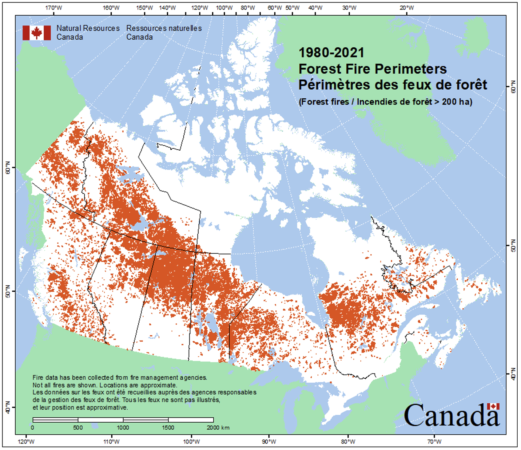
Supported by MITACS and BMO, this project aims to predict wildfire risk across Canada using AI and heterogeneous datasets, which is critical for environmental management and disaster mitigation. By leveraging diverse data sources such as climate records, weather patterns, remote sensing data, and historical wildfire occurrences, AI algorithms can discern subtle spatial-temporal patterns and correlations, enabling more accurate and timely forecasts of wildfire outbreaks. This research aims to improve the current state-of-the-art predictive capability, such that it empowers wildfire management to minimize the devastating impact of wildfires on ecosystems, human settlements, and infrastructure.